Idaho, abbreviated ID or Ida., Is a state in the northwest of the United States. Idaho borders Oregon and Washington in the west, Canada in the north, Montana and Wyoming in the east, and Utah and Nevada in the south.
Idaho has a total area of approximately 216 450 km2, and has 1,716,943 residents (US Census, 2017). Idaho was entered as the No. 43 state in the United States on July 3, 1890, having been part of the Idaho Territory with Montana and Wyoming since 1863. The capital is Boise, which is also the state’s largest city with 226,570 residents (U.S. Census, 2017).
Geography
Idaho is located in the northern Rocky Mountains, which form more than 80 smaller mountain ranges within the state. The state lies west of the main water divide and drains to the Pacific through the Snake River with bees, which in several places cut into deep canyons (including Hells Canyon, the deepest in North America). In the west form the Snake River on a stretch border with Oregon and Washington. Most of the border with Montana in the east is formed by the Bitterroot Rangewith several peaks exceeding 3000 meters, including Scott Peak (3472 meters). Idaho’s highest peak is Borah Peak (3859 ft.) In the Lost River Range mountain range. The southwestern part of Idaho is an elevation between 1200 and 1800 meters above sea level. To the southeast lies the Desert Snake River Desert with the Craters of the Moon National Park, with a quaint volcanic landscape reminiscent of the lunar surface.
The high mountains close to cold air masses from the east and allow mild Pacific air to penetrate most of Idaho from the west. The average temperature in the capital Boise (870 m) is –2 °C in January and 24 °C in July. Annual rainfall varies between 250 mm in the plain and 1000 mm in the mountains.
Population
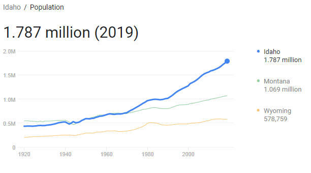
Idaho has a rapidly growing population and in 2016–2017 was the fastest growing US state in percentage growth (US Census, 2017). In the decade 1970-1980, the population grew three times faster than the national average. Growth continued in the 1980s and in the 1990s the population increased by 28.5 per cent. From 2000 to 2010, growth was 21.1 per cent. Only about half of the population is born in the state. “Quality of life” is often stated as a reason for relocation. Politically, the population is quite conservative, and some extremist groups (militias) have attracted negative attention in the national media.
93.2 percent of the population is considered white, including 12.5 percent of Hispanics. The indigenous population, including nez perce and shoshoni, which partly live in reserves, count 1.7 per cent of the population, while blacks make up 0.9 per cent. The state is sparsely populated (7.5 per km2 – number 44 among the states). Urbanization has been prominent in recent years, while just over half of the population lived in cities in 2003, now around 70 per cent live in urban areas. The largest cities are the capital Boise with 226 570 residents, Nampa with 93 590 residents (part of the metropolitan area around Boise), Meridian with 99 926 residents (part of the metropolitan area around Boise), Idaho Falls with 61,076 residents and Pocatello with 55,193 residents (US Census, 2017).
Idaho elects two senators and two members of Congress in Washington DC. The state’s own Senate has 70 members, the House of Representatives 35 members.
Business
Agriculture is today bypassed by industry as its main trade route, but still plays a major role. The agricultural area covers approximately 1 / 4 of the state’s area. Of this irrigate approximately 1 / 4 using large sprinkler. The main product is potatoes (Idaho is the largest potato producer in the United States, and is also known as the “potato state”). Wheat, sugar beets, alfalfa, oats, barley and apples are also grown. Forests cover close to 2 / 5 of the land and forestry is an important industry branch.
The mining operation takes place especially in the north. The main products are lead, silver, zinc, copper and phosphates. Gold, which gave support to the mining industry in Idaho, is now of less importance and is extracted substantially as a by-product of the production of other minerals. Modern mining in central Idaho, especially in the McCall area, is based on beryllium, vanadium and thorium. The mining industry was previously often haunted by labor conflicts, and both populist movements and the radical trade union IWW stood strong here at the turn of the century.
In 1975, a channel from the Pacific to Lewiston in the northwest, the Columbia – Snake River Inland Waterway, was opened and provided wheat farmers in the northeast with access to the ocean.
The industry works to a great extent with the processing of the state’s own agricultural, forestry and mining products. The numerous national parks have provided the basis for large tourist traffic. Part of Yellowstone National Park is located in the state, and especially visited are the scenic lake lands around Coeur d’Alene and Craters of the Moon.
History
Originally, today’s Idaho was populated by indigenous people shoshoni, paiute and nez perce. The Lewis-Clark expedition in 1805–1806 was followed by fur hunters and trading stations. The gold rush after 1860 created great influx, including that of Mormons, which dominate the southeastern part of the state today.
Idaho belonged for a long time to the Oregon Territory, which the United Kingdom claimed in 1846. The area then came under the United States, and colonization began in 1860, while gold was found in the area. In 1863, the area (along with the later state of Montana and most of Wyoming) was organized as its own territory, then to become the 43rd state in the Union on July 3, 1890.
The mining industry was often affected by labor disputes in the 1800s and early 1900s, and both populist movements and the radical trade union organization IWW stood strong here at the turn of the century. The ties to Utah Mormon State are still strong.